Struggling Against Sprawl in Rutherford County
By Dave Rollo
Rutherford County is located in the central Tennessee farm belt. Its county seat, Murfreesboro, is precisely in the state’s geographic center, and it briefly served as Tennessee’s capital. But, because of greater commerce and superior roads, the legislature chose Nashville as the seat of power only a few years after statehood was granted in 1796. Decades later, Murfreesboro became a grim center of the Civil War. It was the site of the Battle of Stones River—a pivotal Union victory bought at the cost of immense casualties.
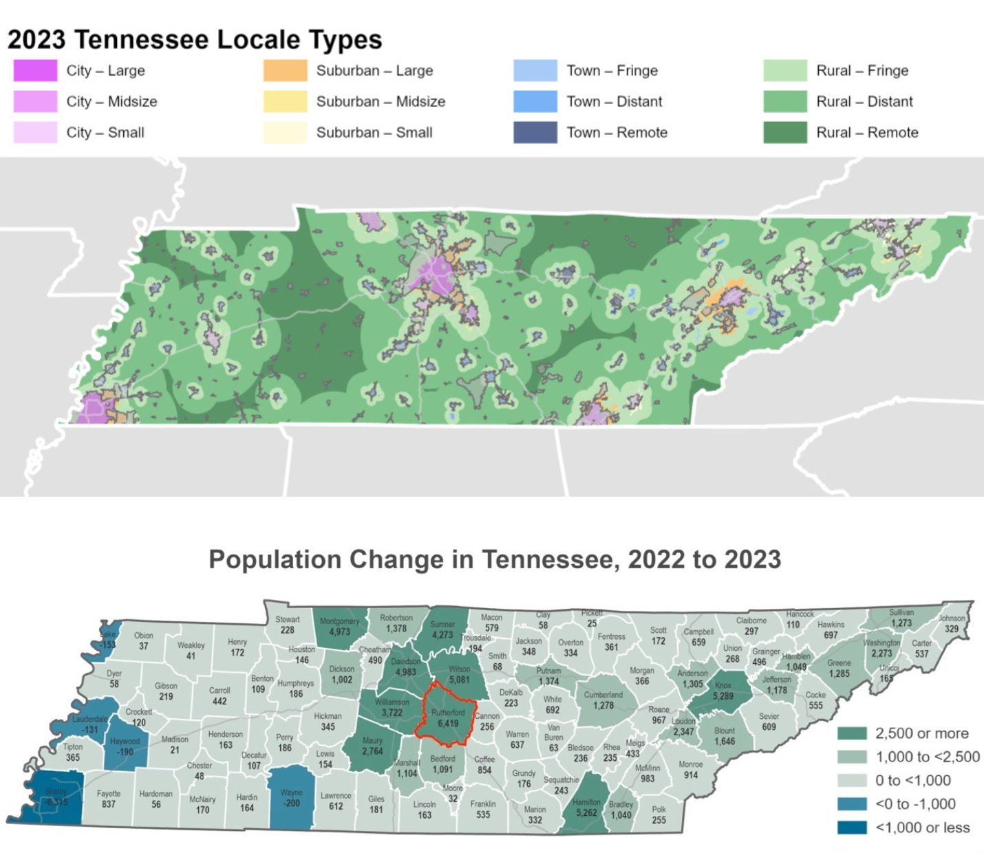
Rutherford County (outlined in red) has experienced the greatest population growth of all 95 Tennessee counties in recent years. (Tennessee State Data Center, Public Domain)
Today, a different kind of struggle defines the region, with Rutherford County again at the epicenter: rapid urbanization converting farmland to pavement and housing. The county is rapidly being absorbed into a megalopolis that includes Nashville, Davidson, Murfreesboro, and Franklin. This cluster of municipalities ranks among the fastest-growing in the nation. Runaway population growth and inadequate land planning are driving rapid sprawl, exceeding existing infrastructure capacity and eliminating high-quality farmland.
In many ways, Rutherford County is a microcosm of a national divide between developers profiting from unchecked expansion and residents whose quality of life is eroded by it. In an attempt to secure a more sustainable future, county officials recently revised their comprehensive plan to obviate sprawl. Yet, the proposed land-use limitations faced fierce blowback in the final days of the adoption process.
As local officials weigh eleventh-hour compromises that threaten to dilute the work of good-faith planners, the effectiveness of the entire plan hangs in the balance. For Rutherford County, a defining choice is only weeks away.
A Late Start
Comprehensive plans are important guiding visions that may also specify land-use parameters, such as density (number of units per acre). Rutherford County adopted its first comprehensive plan in 2011. This gave the county a late start; many counties developed theirs decades prior. The 2011 plan was followed by a zoning ordinance—a set of legally binding land-use regulations—in 2013.
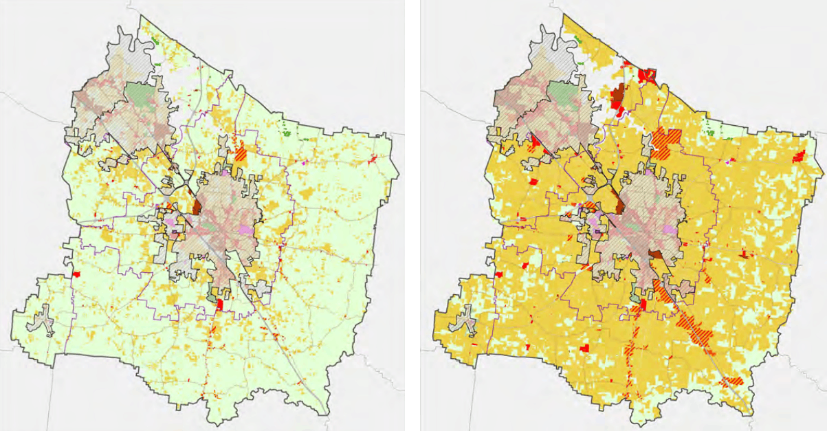
Rutherford County land-use map from 2008 (left), with undeveloped parcels in green, residential developments in yellow, and commercial areas in red. The map on the right shows a 2035 projection with unrestrained development. (2011 Rutherford Comprehensive Plan, Public Domain)
Designed to guide development for 20 years, the 2011 plan was soon outpaced by the county’s rapid growth. It succeeded, however, in highlighting an alarming trend: Maps showed that without further government intervention, nearly all undeveloped parcels would be swallowed by residential development by 2035.
Moreover, even as the county adopted the 2011 plan, growth was already creating traffic gridlock and overcrowding in schools. Within a decade, planners began work on an alternative PlanRutherford to address the shortcomings of the original comprehensive plan. The county’s 10-member Planning Commission is responsible for creating the new plan in coordination with the Planning Department.
Alarm Bells
Rutherford County has a current population of 377,000 inhabitants, and Planning Director Doug Demosi projects it will surpass 550,000 by 2045. Such a large population increase will bring corresponding stress on infrastructure, increases in flooding risks, and loss of farmland and other open space. For PlanRutherford, planners assessed likely outcomes under various scenarios. The outcomes of the baseline trend are startling.
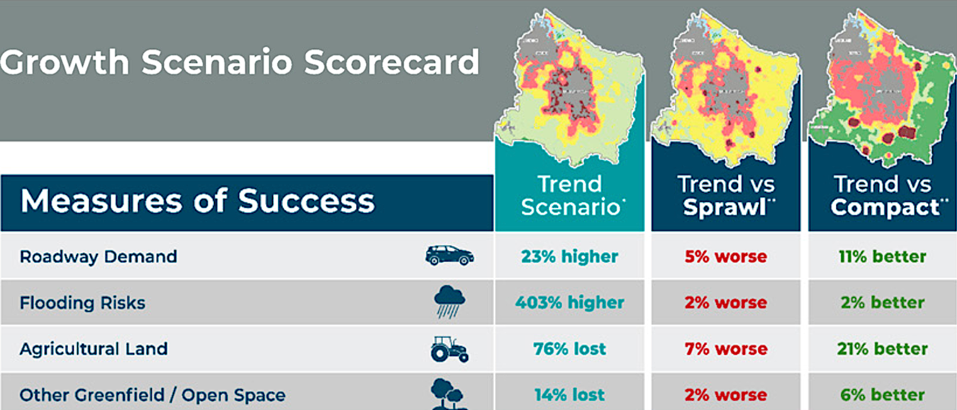
A portion of a “Growth Scenario Scorecard” from PlanRutherford showing outcomes of the likely trend scenario, with “Sprawl” and “Compact” scenarios based on land-use decisions. (PlanRutherford, Public Domain)
Rutherford County residents should expect over 400 percent greater flooding risks, with a 76 percent loss of farmland, under current trends. To illustrate other scenarios, PlanRutherford includes a Growth Scenario Scorecard with various “measures of success” under sprawl and compact land use.
The sprawl scenario is only incrementally worse than the baseline trend, indicating that sprawling land use is already in place. Alternatively, the county could realize modest gains under the compact scenario. This would entail reducing density in rural areas and concentrating development within nodes where infrastructure already exists.
Planners used these projections to develop a proposal for zoning changes, included in PlanRutherford. The proposal reflects an attempt to mitigate the worst-case scenario while accommodating current trends. In other words, it is a classic “smart growth” proposal for zoning that would, modestly, lower rural density relative to what it would otherwise become.
A Very Modest Proposal
On January 22, 2026, the county elected body, the Rutherford Board of Commissioners, met to determine whether they would accept the final draft of PlanRutherford. Planning Director Demosi presented on the intent of the plan: managing growth. He focused primarily on the plan’s Future Land Use Policy chapter. This policy includes three major area designations: Rural Preserve, Rural Living, and Country Suburban.
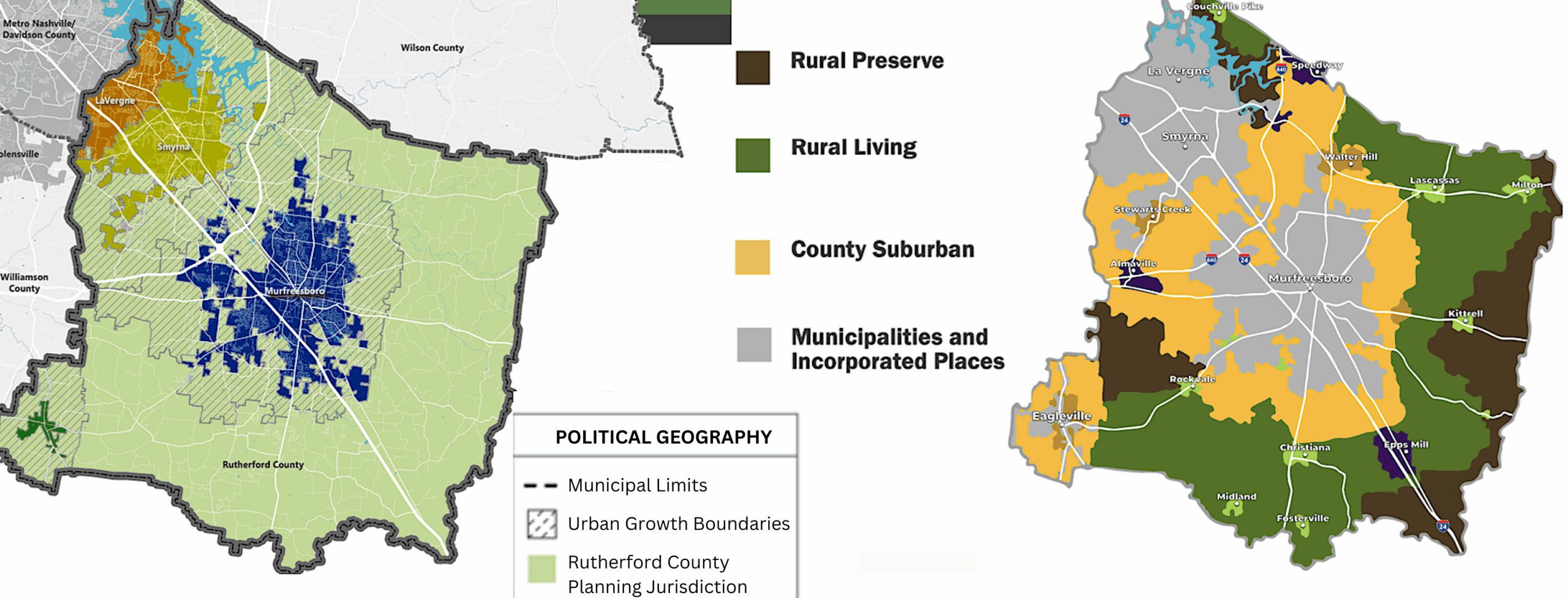
The land-use map on the left shows the urban growth boundaries of the municipalities within Rutherford County, and the map on the right shows the three area designations proposed in PlanRutherford. (PlanRutherford, Public Domain)
Fully half of the county has already been designated as urban or is within the urban growth boundaries of La Vergne, Smyrna, Eagleville, and Murfreesboro municipalities. The area proposed for the Country Suburban designation falls mostly within these boundaries. The new designation would allow up to three units per acre. This is not a substantive change from the Rural Medium-Density designation, under which much of this area currently sits.
With the Rural Preserve designation, planners intend to reduce development density on the periphery of the county. This designation would allow 1 residential unit per 5–15 acres. (Planners would determine precise limits when crafting zoning code.) The current Rural Low-Density designation allows 1 unit per 1–5 acres. This zoning change would help maintain the agricultural and cultural character of the county’s most rural areas.
Planners also propose the Rural Preserve designation for the area surrounding the local J. Percy Priest Reservoir. This would create a buffer area to protect the county’s water supply. The proposed Rural Preserve areas only occupy about 15 percent of Rutherford County and are all currently designated Rural Low-Density.
The Rural Living designation represents the largest area of proposed density change in PlanRutherford. According to Demosi, it has also been the most contentious in the revision process. In an attempt to establish a lower density transition area between County Suburban and Rural Preserve, planners proposed a limit of 1 unit per 1–5 acres (depending on proximity to services). The existing zoning in that area allows between 1 unit/acre and 3 units/acre. The proposed density reduction drew the ire of landowners and developers alike.
To Retreat or Stand Firm?
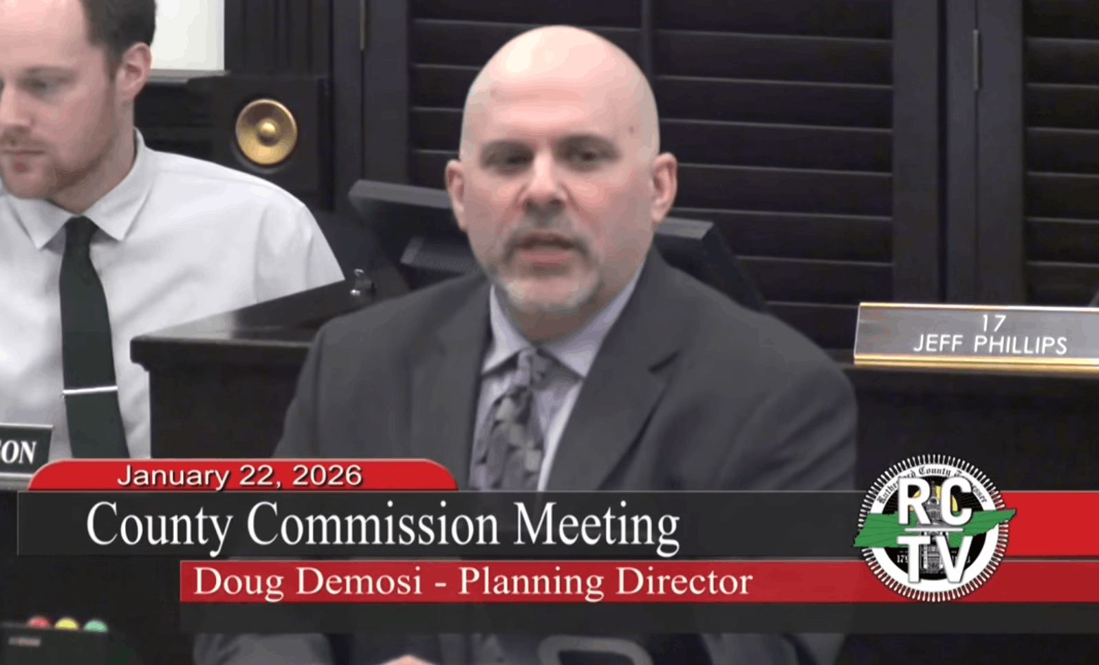
Planning Director Doug Demosi speaks about PlanRutherford at the January 22 meeting of the Board of Commissioners. (Rutherford County TV)
There was a laborious review process involving those objecting to land-use restrictions and those favoring restrictions to preserve a rural quality of life. Planners attempted to reach a balance acceptable to all parties. As Planning Commissioner and Road Board Member Michael Shirley stated, the Planning Commission is a “body that includes farmers, business owners, home builders, real estate professionals, and four sitting [members of the Board of Commissioners]. These members bring very different perspectives and priorities to the table.”
Shirley averred that “[PlanRutherford] is not rushed, and it is not incomplete. It is the result of more than four years of work. During that time, it has gone through multiple public input events, public comment periods, Planning Commission debates, workshops, formal public hearings, additional amendments, compromises, and ultimately a final vote. When that vote occurred, the plan passed the Planning Commission unanimously.”
Initially, the Board of Commissioners did not pass the plan due to developer pushback. This was despite impassioned testimony from supporters of the draft plan during a four-hour meeting. The Board voted 12–9 to amend the plan, sending it back to the Planning Commission for reconciliation. The proposed amendment was to increase the density in the disputed Rural Living area to 2 (instead of 1) units per 1–5 acres.
The Planning Commission had a decision before them: Amend the plan with the recommended density increase or return it with no change. They met on February 23 and resolved to keep the plan as is—with the lower density. The ball is now in the Board of Commissioners’ court, with a final decision due by mid-April.
The Downzoning Dilemma
At the current pace of land conversion, Tennessee loses an estimated 10 acres of farmland every hour. Concerns have prompted the governor and the state legislature to enact a Farmland Preservation Act. The law pledges $25 million to incentivize farmers to place their land in conservation easements.
With over 63,000 farms in Tennessee, the $25 million equates to less than $400 per farm. Critics say that’s not enough to deter developers from offering higher incentives for land. The scale of loss, fueled by high land values, is overwhelming the state’s incentives.
Furthermore, offering money to conserve land is a classic case of the “trophic conundrum.” Money can be spent on conservation in one area, but generating the money entails an ecological footprint in another area. In the big picture, then, true conservation can hardly be bought. Land-use control via zoning must be part of the remedy.
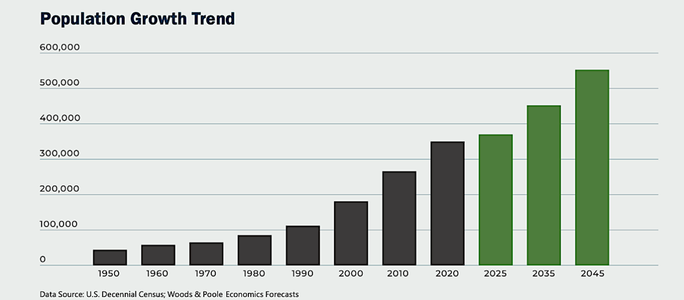
Rutherford County’s population has roughly doubled every twenty years since 1990. (PlanRutherford, Public Domain)
Like Rutherford, many counties facing runaway growth, in Tennessee and elsewhere, attempt to limit impacts via “downzoning.” Reducing building density on undeveloped natural and rural land can prevent county services and infrastructure from being overwhelmed and protect the environment and quality of life. But powerful development interests make downzoning politically risky and legally challenging. They may threaten lawsuits on the basis of a takings: a limit to productive land use and value without adequate compensation.
Downzoning is especially challenging once growth has escalated land values. Because Rutherford County began so late to protect its rural and natural areas, planners working to limit development are at a profound disadvantage. With many landowners expecting to cash in on the boom, it’s not easy to push back on development. Modest “smart growth” has become the fallback position.
Leveraging Concurrency
The concept of concurrency is a powerful tool for policymakers facing tough decisions regarding growth. Simply put, concurrency is the timely provision of public goods relative to the demand for them. Local governments can leverage the idea of concurrency to help residents understand that public services and infrastructure—schools, roads, water resources, and parkland—often cannot keep up with unabated growth.
Applied to policy, concurrency can take the form of Adequate Public Facilities Ordinances. These ordinances prevent development if public infrastructure cannot accommodate it. Various locales have implemented moratoriums on new development to prevent exceeding the capacity of county infrastructure or services.
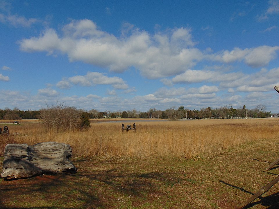
Civil War cannons stand as sentinels in defense of Murfreesboro at the Stones River National Battlefield, which is now surrounded by housing sprawl. (Wikimedia Commons, CC BY-SA 4.0)
Another tool is to challenge the idea that downzoning inherently diminishes land value. Some analyses have shown that downzoning can preserve land value. Reducing the intensity of land use can increase land value as open areas become rarer. This scarcity effect can also maintain or boost the value of surrounding properties due to a desire to live adjacent to open land. Conversely, sprawl often diminishes land values by increasing pollution, crowding, noise, and crime. These negative impacts of sprawl often don’t make it into land-value calculations, but they should. And there is a point where civic leaders need to say “enough.”
Sprawl isn’t the only challenge to Rutherford County. In the not-so-long run, “heat, precipitation, and fire” are in the cards due to runaway greenhouse gas emissions. And in the longer run? One recent cli-fi title featured Murfreesboro for a story of survival in the year 2145.
According to the narrative, Murfreesboro is positioned barely north of a vast uninhabitable region called “Mesoland,” after the temperatures of the Mesozoic Era (the Age of Reptiles). It’s a scary story in which the county is protected from exceedingly threatening species only by the poorly patrolled “Mesoland Containment Corridor.” 2145 is fiction, not climate science, but it’s worth noting that the author (Peter Seidel, 1926-2025) was a long-time student of climate trends and a renowned city planner.
Climate planning may seem like a stretch when county planners are still struggling with the ongoing issue of sprawl. But it’s worth at least keeping the effects of climate change in mind—whether irritating or devastating—while planning and zoning for hundreds of thousands of new residences.
Rutherford County is at an important turning point. It is concluding a nearly five-year process of developing a comprehensive plan to mitigate threats to the county’s culture, quality of life, and environment. It will need to take steps, however modest, in the right direction to preserve any land for farming, recreation, and natural systems. A lesson for other counties: Keep your county great by being proactive, and downzone sooner rather than later. Otherwise, how will you protect your farms and forests when the GDP bulldozer arrives?
 Dave Rollo is a policy specialist and team leader of the Keep Our Counties Great campaign at CASSE.


Oh man, I hope sanity prevails on this one. I will keep my fingers crossed.