Charleston County’s Greenbelt Success
by Dave Rollo
Counties facing growth challenges can use a variety of tools in their land-use planning to prevent sprawl. One tool is a “greenbelt” composed of a ring of natural and agricultural land that is conserved to hem in urbanization.
Greenbelts have long been a popular planning method in Europe. Researchers at Concordia University compared 30 European cities with greenbelts to 30 without. They found decreases in urban sprawl in almost all of the greenbelt cities. Fewer examples exist in the United States, but the Charleston County Greenbelt Program serves as a leading domestic model.
Located along the Atlantic seaboard, Charleston County is South Carolina’s largest county by land area. It stretches over half of the state’s 187 miles of coastline. Two of the state’s three largest cities, Charleston and North Charleston, are located in the county, creating substantial growth pressures. North Charleston has expanded into neighboring Dorchester and Berkeley Counties.
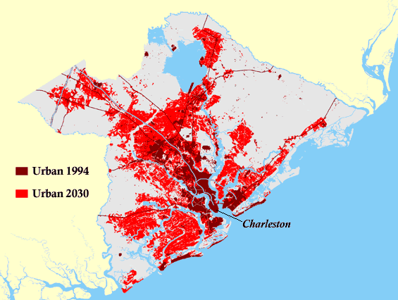
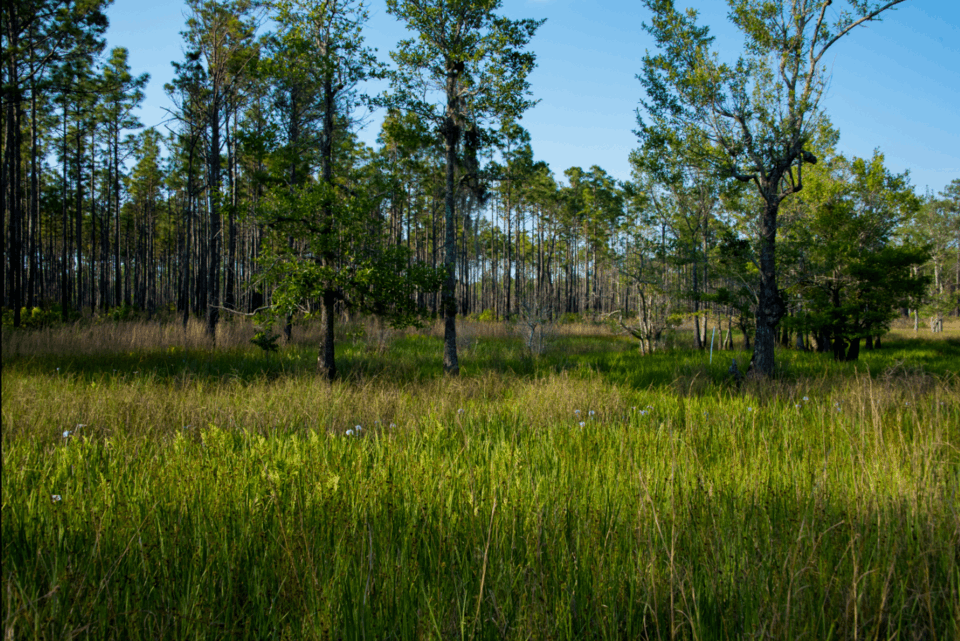
The greenbelt program has kept this urban-expansion prediction from the mid-1990s from coming true. (Berkeley-Charleston-Dorchester Council of Governments)
This urban expansion was first quantified and raised as an urgent concern in 1997 by the Berkeley-Charleston-Dorchester Council of Governments. Remote-sensing imagery revealed that between 1973 and 1994, urbanization of land outpaced population growth by more than sixfold. This finding alarmed regional planners and elected officials as it indicated a further expansion of 250 percent in area by 2030 if left unchecked. In response, the county created a funding mechanism to address lagging infrastructure and loss of greenspace.
Today, the Charleston County Greenbelt Program stands as a premier example of how proactive land conservation can prevent worst-case growth. The program has secured over 28,000 acres, safeguarding natural systems while supporting rural livelihoods and public recreation. Yet, this innovative, voter-backed funding model faces an inherent tension. Its dependence on transportation dollars may lead to contradictory infrastructure, undermining conservation goals.
Envisioning a Green Network
By the early 2000s, growth had led to infrastructure deficiencies in Charleston County. In response, officials proposed a way to fund road repair and expansion: a sales tax of 0.5 cents on a dollar for 25 years. The funds would be devoted to transportation infrastructure (roads, bridges, and highways) and to the county’s mass transit system. Some of the revenues would go to maintenance, but some would be utilized for roads accommodating new development.
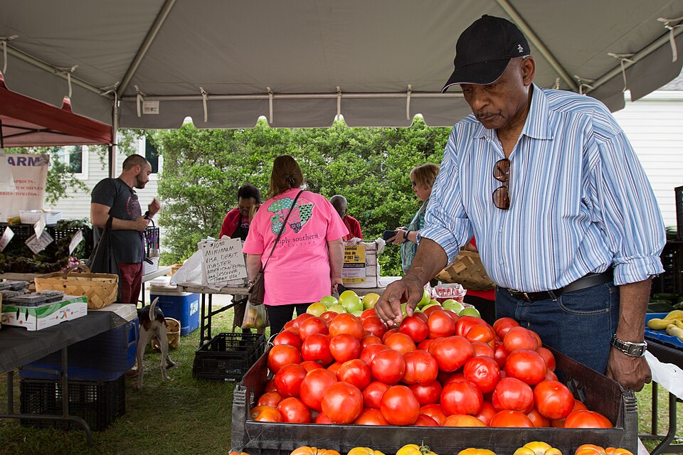
A vendor at the North Charleston Farmers Market. (North Charleston, CC BY-SA 2.0)
Citizens and conservation groups recognized that the development of roads and the disappearance of greenspace, both of which were accelerating, are intrinsically linked. They lobbied the county government to include greenspace protection in the expenditures. This message resonated well with voters and, in 2004, the tax was adopted by referendum.
The goal described in the referendum was to protect the most vulnerable properties to ensure at least 30 percent of the county’s total land area remained green. When the plan for achieving this goal was developed, 160,000 acres were already protected. Most of the protected area was in the Francis Marion National Forest or in coastal areas such as the 66,000-acre Cape Romain National Wildlife Refuge. The county aimed to secure at least another 40,000 acres.
Officials decided to allocate 63 percent of the new tax revenue to transportation infrastructure, 20 percent to public transit, and 17 percent to greenspace protection. The expected revenue for the greenspace program over the 25-year duration of the tax was $221 million.
The Greenbelt Plan Takes Shape
After the referendum passed, the Charleston County Council appointed a 14-member Greenbelt Advisory Board (GAB). The board conducted comprehensive public outreach, surveying county residents and then creating a Comprehensive Greenbelt Plan in 2006. The executive summary of the plan described Charleston County as standing at a “turning point” because of the growth trajectory and the need to preserve land.
The Comprehensive Greenbelt Plan, as adopted in 2006, was ambitious. Reflecting the needs of county residents, it established six types of greenspaces for protection:
- Passive greenspace: parks with limited trails for recreation and education;
- Natural resources: upland forests, wetlands, and riparian areas;
- Heritage landscapes: historic and cultural sites;
- Productive landscapes: agricultural land;
- Natural infrastructure: land providing substantial ecosystem services, such as tidal marshes, which protect ecosystems and communities from hurricanes; and
- Active greenspace: more-developed parks and athletic fields.
The document also included plans for corridors to connect greenspaces.

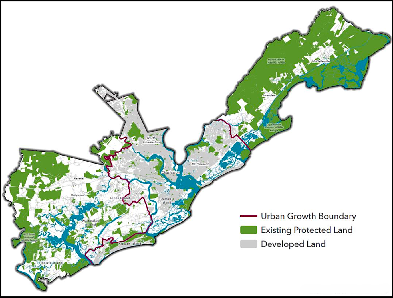
The green bullseyes represent greenbelt land acquisitions where public access is permitted (private acquisitions aren’t shown). (Charleston County Greenbelt Program)
Since 2006, the GAB has considered the protection of these land types when evaluating applications for funding. Furthermore, the transportation-tax legislation mandated that 70 percent of the greenbelt funding be allocated to land in rural areas. The remaining 30 percent goes to land within the City of Charleston’s urban growth boundary (UGB).
The GAB serves as the sole advisory body to the county council for urban and rural funding. Eric Davis, the director of the greenbelt program, told the Steady State Herald that the county doesn’t use the program to purchase and own land. Rather, other groups, such as municipalities, conservation organizations, land trusts, landowners, and businesses, submit proposals for grants to protect land.
Moreover, according to Director Davis, the program’s impact is rooted in its ability to multiply public investment. “Matching funds are very important to our program. We want our funds to leverage additional funds, and the scoring by the GAB reflects that.” To date, the program has attracted more than $240 million in matching funds, including state, federal, and local government grants, landowner donations, and partner grants.
Progress and Controversies
Over the past two decades, the greenbelt program has protected over 28,000 new acres. About two-thirds of this land is protected by conservation easements—legally binding restrictions on development. The remaining acres have been purchased in fee simple, transferring full ownership to organizations like land trusts. By 2016, a progress analysis indicated the county was well on its way to protecting 30 percent of its land.
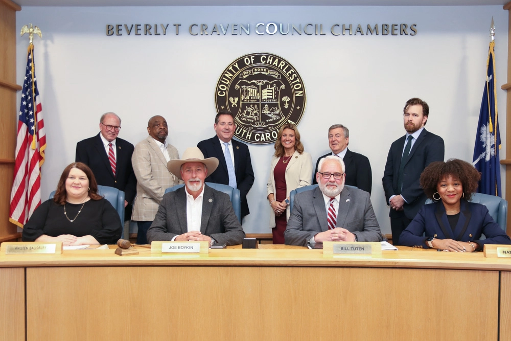
The Charleston County council determines how much funding flows to the greenbelt program. (Charleston County)
The county council resolved to expand the program by increasing the transportation tax to one cent on a dollar. There was another referendum in November 2016. It passed by 52 percent of votes cast, significantly less than the 59 to 41 percent margin of support in 2006.
Though the revenue stream increased, the council chose to reduce the share allocated to the greenbelt program from 17 to 10 percent. Even so, the program was expected to accrue an additional $211 million by 2042.
But another change fundamentally altered the program. The county changed the 70:30 rural-to-urban allocation to 50:50. Land acquired in urban areas tends to be public, while land acquired in rural areas tends to be private. Director Davis explains, “There has always been a bit of tension between land that allows public access, and private land protections. Some of our county council members don’t see as much value in a private conservation easement.”
These changes have caused concern, particularly from land-trust organizations. Preservationists see the time horizon for saving rural land shrinking. Public sentiment may align with these views, given the failure of a 2024 referendum for another half-cent tax increase. That funding was intended for a multi-billion-dollar expansion of Interstate 526 into the Charleston Peninsula. Critics argued this pro-growth project would fuel over-development and suburban sprawl.
Modifying the Model
The next step in the Charleston County Greenbelt’s evolution may come this fall. The county council is considering yet another attempt at a tax increase, with the details currently in development.
Although efforts to protect undeveloped land have yielded success, much remains to prevent sprawl, protect wetlands, and maintain biodiversity in Charleston County. (Lowcountry Land Trust)
In anticipation of the coming tax, an impressive consortium of conservation groups produced a report on the land preservation necessary to protect the county’s ecological integrity. They determined that over $750 million in additional funds are needed to protect the ecological integrity of rural areas (outside the UGB). They noted that protecting land inside the UGB costs some 15 times more per acre than protecting land outside of it. They implied that the county should reconsider the 50:50 split in revenue allocation.
However, at a meeting two days ago, the council approved the 50:50 split. That said, three public hearings will provide opportunity to amend the ordinance and ballot language before the referendum.
Matt Williams, President and CEO of the Lowcountry Land Trust—the main author of the report—noted in a Steady State Herald interview that the time is ripe for greater commitment. Greenbelt initiatives can be more effective by leveraging new state funding, according to Williams. In early 2026, Republican Governor Henry McMaster has championed a “10 Million Acres” initiative. The goal is to triple the present 3.2 million acres with some status of protection to 10 million acres—half the area of the entire state.
Williams described a nexus of state and county funding that could multiply land protection dramatically: “It’s exciting what has been accomplished over the past years. We have support from the public for expanded greenbelt funding in Charleston County and neighboring counties. And, we have a shared bipartisan sentiment at the statehouse. This has led to more success for land protection, but there’s still so much left to do.”
If the Charleson County council doubled the current amount of transportation tax revenues allocated to the greenbelt program, from 10 to 20 percent, it would result in around $850 million. This could go a long way toward realizing the goal of the conservation groups. And public survey results indicate solid support for land protection to stave off development pressures.
At their April 28 meeting, the council took the middle road, approving 16.24%, or around $690M, for the greenbelt program. Again, three public hearings will provide opportunity to amend this decision before the referendum.
Future Challenges
The coming months will be crucial in determining the future of what has been a model for land protection. Since Charleston County established its greenbelt program, surrounding counties have followed suit. Berkeley and Dorchester Counties approved greenbelt programs through a similar taxation process in 2024.
The Francis Marion National Forest is an important northern obstacle to sprawl in Charleston County, South Carolina. (Melanie Olds/USFWS)
A greater share of the proceeds of the tax, if directed to rural and ecologically sensitive land, will render a better outcome for sustainability. And, transitioning taxes to limit transportation projects to maintenance of existing roads and public transit would be a superior strategy to preserve biocapacity. That approach may win public support, given the skepticism in the county about expanding superhighways.
Even then, it may not fully align with steady-state principles to fund the preservation of natural areas with taxes derived from the very economic activity that threatens natural areas to start with. To evolve to a steady state, we must resolve the “trophic conundrum” that reduces biocapacity in one area to preserve it in another. This is one of the arguments for conservation by regulation (in contrast to a market approach).
That said, the major up-front expenditures (fee title and easement procurement) for greenbelt designation are one-and-done, solving some of the trophic conundrum when greenspace acquisition is completed. Management of greenspace and enforcement of regulations entails ongoing expenditure, but political leadership and community support—such as volunteerism, honoring easement terms, and public adherence to greenspace regulations—can make greenspace maintenance sustainable.
 Dave Rollo is a policy specialist and team leader of the Keep Our Counties Great campaign at CASSE.

")


Great story. Thank you for pulling it together and sharing it!
Very cool stuff. I am thinking that if we can embrace more walking-friendly communities, a lot of the pressure for development sprawl could ease. Hopefully we’ll see communities evolve to be more walkable, gradually more compact, and less likely to breach the greenbelt.
In the north Paris suburbs, I’ve seen greenbelt ideas as it affects us locally. Our city official in charge of housing told me that the increasing densification of our small city, Clichy, that borders Paris, is necessary in order to protect farmlands 16 miles beyond from being eaten up by housing. That means our city of Clichy has become a 5-minute city. My friend Jean, 92 years old, aided by a cane, is able to do shopping for necessities on foot. Meanwhile the farmlands beginning 16 miles north look almost the same as they did when Van Gogh painted them around Auvers-sur-Oise, where he lived in a simple room. I wonder how residents of urban Charleston would feel about having their city become significantly more compact … and walkable. I assume that some type of organic densification must be taking place within Charlston’s urban growth boundary.